New research paper offers a new workflow for processing LiDAR data
Biodiversity monitoring with the aim of conservation and restoration of ecosystems depends on accurate quantification of its structure and composition. The Light Detection And Ranging (LiDAR) - an active remote sensing technique - can provide detailed and high resolution information on the actual state of ecosystems.
LiDAR creates three-dimensional point clouds from which metrics of vegetation structure (e.g. height, cover, and structural complexity) can be derived. The challenge is processing those clouds into geospatial data products of ecosystem structure in light of the large volume (usually in terabytes) of national or regional point cloud datasets.
A new publication titled “Laserfarm – A high-throughput workflow for generating geospatial data products of ecosystem structure from airborne laser scanning point clouds,” co-written by MAMBO partner Daniel Kissling from the University of Amsterdam (UvA), addresses this challenge. The publication presents a high-throughput workflow called ‘Laserfarm’, which allows for the efficient, scalable and distributed processing of multi-terabyte LiDAR point clouds.
Furthermore, ‘Laserfarm’ offers a free open-source workflow available to use on different computing infrastructures, including high performance computing clusters and cloud computing environments. The workflow is designed with horizontal scalability and can be deployed on different infrastructures.
The data generated can be applied in ecological analyses (incl. the monitoring of animal diversity), the prediction of species distribution and ecological niches, as well as the monitoring of a globally consistent set of ecosystem structure variables at regional scales.
‘Laserfarm’ is unique with the flexibility and extendibility of its workflow, which allows users to expand the set of features to other metrics such as topography descriptors, neighborhood calculations for detecting archeological remnants, or indicators of ecosystem conditions (Fig.1).
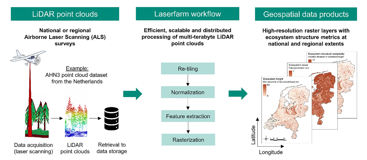
Fig.1. The Laserfarm workflow enables the efficient, scalable and distributed processing of multi-terabyte Light Detection And Ranging (LiDAR) point clouds from national and regional airborne laser scanning (ALS) surveys into raster layers of ecosystem structure. The Laserfarm workflow is exemplified with a country-wide LiDAR point cloud dataset from the Netherlands (AHN3).
As a project dedicated to innovating new approaches for biodiversity monitoring, MAMBO can benefit from this research on the ‘Laserfarm’ workflow. New technologies such as LiDAR are becoming increasingly sophisticated in terms of its design and the possibilities they offer for monitoring and modelling the structure of functioning ecosystems and their biodiversity.
Further information can be found in the original publication on the journal's website here.